
Seasearch Data
We collect data during surveys, but what do we do with it?
What data do we have that YOU could use to make a positive change?
Image by Ben Lamming
Data submission and QA
Seasearch diving and recording are carried out by volunteers. Many of them have a professional background in marine biology and conservation but many do not and are self-taught naturalists.
The data is submitted to us on Seasearch observation and survey recording forms and collated by regional coordinators. The table to the right gives a breakdown of the number of survey events by country or region since 2008. This is an underestimate of the number of actual dives, because multiple similar forms from the same place and time may be merged into a single event. We also have specialised recording forms for seafans and sea cave entrances (the latter in Scotland only).
Templates for forms can be downloaded from the Record page as PDFs to print out or complete digitally. When complete, please send them to us.
We have in place QA processes which are used to validate and verify Seasearch data so that they can be used with confidence. We have a commitment to ongoing data management whereby errors reported to us can be investigated, rectified as appropriate and the dataset updated.

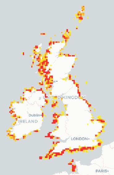
Deciding where to go?
Use this map to identify areas that have been visited only once by Seasearch volunteers (red squares). Data from these sites can not yet be used to generate species trends. Adding a second visit to the site will enable that area to contribute to the models that predict species trends. Let's try and turn some of the red squares to blue!
N.B. It can take a few seconds for data to load. It does not yet work well on small mobile devices like phones.
Explore your Seasearch records
Use this app to explore your Seasearch records. You can filter the records by any combination of year, species and surveyor name.
N.B. It can take a few seconds for data to load. It may not yet work well on small mobile devices like phones.
Where has Seasearch been?
You can view annual summary maps for the positions of Seasearch surveys (each year from 2001 to 2020).
Go to summary mapsHow to acknowledge use of Seasearch data
All Seasearch data and reports are open-access (freely available to anyone), but if you use them, please make sure that you provide appropriate acknowledgement.
To cite use of Seasearch records, please use one or more of the following:
Seasearch (year). Seasearch Marine Surveys in England. Occurrence dataset https://doi.org/10.15468/kywx6m accessed on insert date.
Seasearch (year). Seasearch Marine Surveys in Scotland. Occurrence dataset https://doi.org/10.15468/0hyjxi accessed on insert date.
Seasearch (year). Seasearch Marine Surveys in Wales. Occurrence dataset https://doi.org/10.15468/4us2hk accessed on insert date.
Seasearch (year). Seasearch Marine Surveys in Ireland. Occurrence dataset https://doi.org/10.15468/pyugge accessed on insert date.
Seasearch (year). Seasearch Marine Surveys in the Isle of Man. Occurrence dataset https://doi.org/10.15468/mxkbcg accessed on insert date.
Seasearch (year). Seasearch Marine Surveys in the Channel Islands. Occurrence dataset https://doi.org/10.15468/0ppp4p accessed on insert date.
To cite Seasearch reports, commissioned research or peer-reviewed literature, please refer to details on the individual documents (available via the reports page.
Data on the National Biodiversity Network
All of the Seasearch species data, and data from earlier Underwater/Marine Conservation Society surveys, are available to use and download from the National Biodiversity Network (NBN) Atlas. Data can be searched for by species or by grid square and you can choose to see just the Seasearch data or data from all of the providers.
The main Seasearch datasets (one for each country) contain over 750,000 species records.
As well as the large Seasearch dataset, there are two smaller datasets. One contains additional records of pink sea fans, Eunicella verrucosa, and associated species. The other contains additional crawfish/spiny lobster, Palinurus elephas, records.
In addition to species data, habitat and biotope data are available in Marine Recorder Snapshot format on request.
Some species are considered to be "sensitive" so those records are shown as a 10km square and the exact positional information is only available on request with justification for use.
Data sharing and use
Seasearch data are distributed under a Creative Commons with Attribution (CC-BY) licence. We want our data to be as widely used as possible, but the source of the data should be properly credited.
The data are made available in three ways:
- Survey reports - download from the Reports section.
- On the National Biodiversity Network Atlas.
- In Marine Recorder snapshot format – either on direct request to Seasearch or by downloading the JNCC public snapshot.
The data flow image shows how Seasearch data fit into the UK and global "data landscape", being aggregated and shared into much larger data portals. The MEDIN portal is where all the survey metadata (data about data) is stored to provide discoverability.

Do you need some help?
There are lots of data in here. Is there anything you specifically need? If so, get in touch.
Help me please!Image by Matt Doggett
